
CA - 1 Cotton Tree
CHARACTER AREA DESCRIPTION
A 19C residential area built around the former Standroyd Mill at the foot of the hills leading up to Colne to the north and west and to Winewall to the east. The Colne Water river and its flood plain provide the setting to this relatively dense built up area.

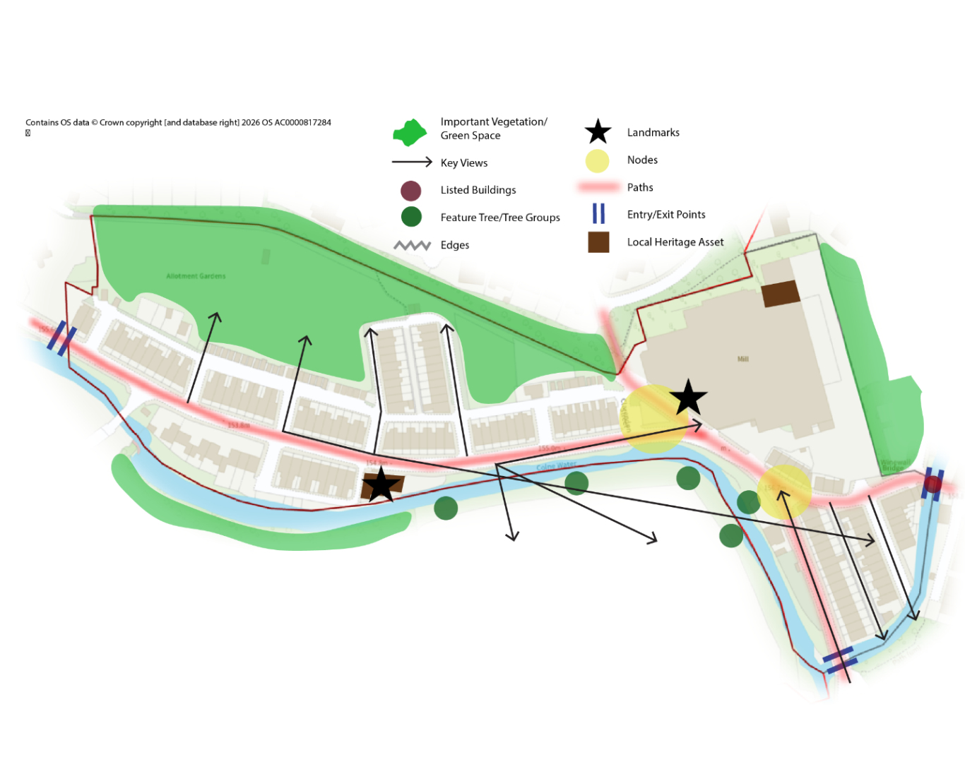
CHARACTER AREA SIGNIFICANCE & EXPERIENCE OF PLACE
- Strong rhythm to street scene with highly regular parallel and perpendicular street layouts
- Terraces of almost identical building and roof forms and dimensions dominate
- Colne Water forms a clear edge to the south, with expansive vista towards Trawden southwards revealed dramatically when travelling eastwards along main road beyond the former Methodist Chapel to where the area meets Winewall
- Strong landscape setting forms a clear edge on its northern boundary to Colne
- Mature trees viewed in glimpses between buildings along Lambeth Street and Hollington Street
- Allotments and garden areas off Lambeth Street and Hollington Street are tranquil spaces ‘cheek by jowl’ with adjoining terraces
- Plots fronting the main road west of Lambeth Street extend over the rear access road to garages and garden areas – a small number of houses have small rear gardens
- Curve in the main road and its tight street profile frame and reveal views of landmarks, views and vistas
- Very clear sense of arrival into the area from east and west at the bridges over Colne Water from Roseley Street in Winewall and from Trawden Road
- The long terrace along Trawden Road (Nos. 1-31) on the right of the long view from the bridge to the former Mill announce the arrival into Cotton Mill from Trawden Brook
- The former Wesleyan School Chapel building is distinct from the uniform terraced houses that surround it and is a landmark
- The large and featureless flank wall of the main building on the former Standroyd Mill site terminates the long views along Cotton Tree Lane in an abrupt fashion but also serves as a landmark
- The Millenium Garden and former tramway route space in front of that flank wall form a subtle but important historic node where this area meets with the Winewall area
- A second node is formed at the junction of Winewall Road and Trawden Road by the buildings that tightly enclose it, i.e. the terraces at Nos. 1-5 and Nos. 6-9 Winewall Road, No. 1 Trawden Road (especially prominent and distinctive with its twin elevations to the roads) and No.2 Holme Street (the prominent gable end and rear elevation of which terminate and lead the view to the left towards the Grade II Listed Winewall Bridge beyond
- The twin elevations of Nos. 10-12 Winewall Road maintain the drama of that view and lead the eye to the Bridge, which is also framed by the tall, mature trees opposite at the entrance to the park – the streetscene here is somewhat diminished by the rear vehicular access to the former Standroyd Mill site
- There are glimpse views of the wooded hillside towards Hill Top and Wellhead framed by Holme Street and the rear access road between the properties on Trawden Road and Holme Street
CONSERVATION AREA APPRAISAL
This Character Area was not analysed in the Trawden Forest Conservation Area Appraisal 2005, but there is reference to the former tramway:
“Evidence of the Trawden tram track is still extant from the Trawden Arms to the terminus at the former Zion Chapel (fig. 2). Some evidence can be seen also alongside Standroyd Mill in Cotton Tree. The former line of the track is defined by a thoroughfare of stone setts and remains an important link with late nineteenth century.”
LISTED BUILDINGS
None
LOCAL HERITAGE ASSETS
The following buildings and structures are considered to meet the criteria for having local architectural and/or historic significance:
- Former Wesleyan School Chapel, Cotton Tree Lane - opened in 1893 and sensitively converted into residential in the 1990s. Local significance derived from its former social value as a community meeting place and from its architectural value, notably its unusual stone surrounds to the tallest windows on the building frontage and its name and date stones on the eastern front gable.
- Former Standroyd Mill building, Winewall Road – Standroyd Mill was built as a steam-powered worsted mill in 1876 on level ground to the north of Colne Water and was occupied by the Hartley Brothers of Standroyd House and by Johnson Holdsworth who together formed the firm of Hartley Bros and Holdsworth. By 1887 the firm, and the mill, had converted to cotton weaving and from 1891-3 onwards the mill expanded considerably, having doubled in size by 1930. Part of the mill buildings remains as an operational part of the site.
DESIGN STRATEGY
Future design management should follow the principles of Form & Style. The Character Area combines dominant building type, lines, forms and heights characteristics with a very strong pattern of street layout, which narrow the opportunity for any significant departure from those characteristics. However, there is a greater degree of scope for innovation in materials and heights in locations that occupy more prominent locations in the street scene.
DESIGN CODING