CA - 4 Village Centre
CHARACTER AREA DESCRIPTION
The historic core of Trawden village and a predominantly residential area but with a number of important community and commercial uses. Focused around the spine of Church Street from the foot of the hill at the confluence of Trawden Brook and Beardshaw Beck to St. Mary’s Church at the top.
CHARACTER AREA SIGNIFICANCE & EXPERIENCE OF PLACE
- Comprises Church Street and Clogg Heads plus the Ash/Lambert grid square terraces
- Steep hill rises from the pub up curved hill to church tower at the top framed by narrow terraced street
- Uniform typology (two storey terrace) with occasional gaps between terrace groups offering glimpse views to hills beyond
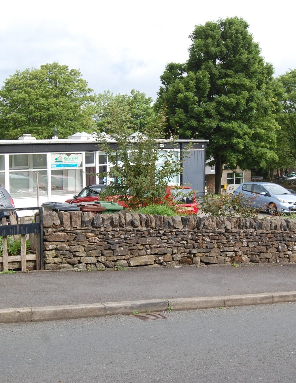
- Blank end of nursery building at main junction in front of church is prominent but detracts, especially in combination with single pitch low garage structure in front
- Common material palette and detailing with some variations and add interest
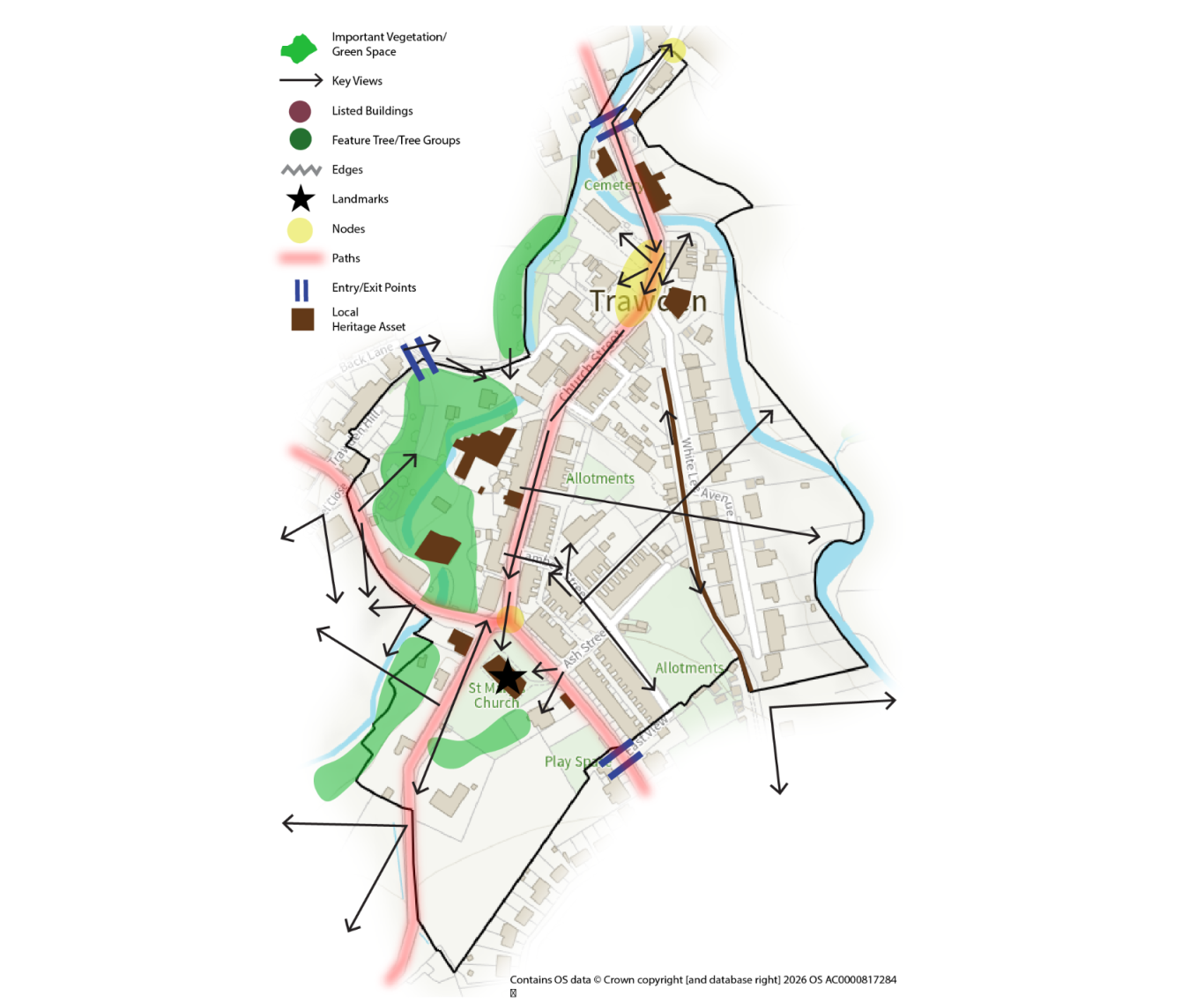
- Long views channelled between terraces of hills beyond (see illustration below)
- Generally follow contours but not Church Street and Ash Street and Clarence Street so sloping front facades and eaves lines (see illustration below)
- Clogg Heads has very different character – some typologies but the layout is even narrower and ‘county lane’ feel with bends and intimate feel – follows part of Beardshaw Beck – land rises steeply on both sides and the north and south west are enclosed
- Commercial centre focused on cluster of social/community buildings at the front of Church Street
- Trawden Arms is very prominent in views from the north (gable end) but part of the group with #44 (angled door elevation), pleasant terrace #48-54 and converted old School House (opposite remnant gravestones on former chapel site in bend in route of Brook)
- Long view up White Lee Avenue – newbuild semis but using the same traditional detailing and materials – former 1.8m tracks of the Colne-Trawden light railway (1903-34) are still visible in coble stone pattern (‘setts’) running from Lane House on the south side downhill to Church Street.
- Extensive vista from the public right of way between Avenue and bus terminus east across the countryside – same sporadic newbuilds but not enough to obstruct – sensitive to any more additions though
- Key node at Colne Road/Church Street junction
- Church tower plays a key role in identifying space but other buildings close to the road edge (and church wall) combine to contain the space – nursery and former Co-op are especially important
CONSERVATION AREA APPRAISAL
From the Trawden Forest Conservation Area Appraisal 2005:
“Victorian Cottontree and Trawden almost merge as a single linear development set in the Trawden Brook valley along the nineteenth century Skipton Road. The townscape is linear and typically Pennine characterized by robust terraced houses and mills (declining in number) set in a valley bottom of green fields, running water and trees. The landscape is interesting and varied with long straight sections contrasting with occasional bends in the road. Unusually, for the Forest, there is a long straight vista and a strong sense of rhythm along the road. There are a number of interesting buildings, including the Trawden “Pissoir” – a Victorian cast iron urinal.
In the south the road rises quite steeply at Church Street which is actually a much earlier road -an extension of Keighley Road that drops down from Stunstead. Here, the townscape is older and more varied as the earlier periods merge with the nineteenth century. The War Memorial and landscaped area adjacent provide a focal point as one begins to climb up Church Street.
The grouping of the terraces is important as they create intimate, enclosed spaces. For example, Clogg Head, a narrow short street, forms such a space with a splayed corner at its Church Street end, which leads through to a winding lane by Beardshaw Beck, rising up a flight of stone steps to the Sun Inn.
The space formed by the buildings along Church Street is small in scale and full of interest, brought about by the difference in the elevational treatment of the buildings. From the bottom of the street at the Trawden Arms it is not possible to see the church at the top. It is with an air of expectancy that one proceeds up the street to see what is around the bend at the top, and one is greeted by the most imposing building in Trawden, the tower of the parish church. Along the way the articulation of the elevations expresses the different designs of the terraces. The frontage of the Old Bakery has not been destroyed, and still retains the stonework to its door and windows. The three-storied building retains its loading door at first floor level.
The School to the Weslyan Methodist Church stands at the bottom of Church Street opposite the site of the former chapel. The building, of high quality stonework, is now in residential use but retains many of its original external features. The former graveyard is sited on the opposite side of the road and provides a point of interest in the street scene. A similar building in character is the Trawden Literary Institute built in 1880. Built with two stories, and set back and partially hidden from the road, the simple form of the building is an important feature of Lane House Lane.
Evidence of the Trawden tram track is still extant from the Trawden Arms to the terminus at the former Zion Chapel (fig. 2). Some evidence can be seen also alongside Standroyd Mill in Cotton Tree. The former line of the track is defined by a thoroughfare of stone setts and remains an important link with late nineteenth century.”
LISTED BUILDINGS
None
LOCAL HERITAGE ASSETS
The following buildings and structures are considered to meet the criteria for having local architectural and/or historic significance:
- St. Mary’s Church, Burnley Road - The Sentence of Consecration by the Bishop of Chester is dated 13th July 1846, being, at this time, in the Parish of Chester. Church Registers began that year. This is an imposing building with an unusual tower. It also contains an impressive entrance and attractive interior. The clock was erected in 1887, the jubilee year of Queen Victoria
- The Old Vicarage and Stables, Carr View - A Victorian vicarage and detached stable block next to St Mary’s Church erected in 1857. The large stable door opening suggests that the Stable was used as a carriage/trap house. There is no obvious evidence of an upper floor having been present in the Stable, so it is assumed that the window above the opening was for the provision of light only and was not used as a forking-hole.
- War Memorial, Hill End - The Parish War Memorial erected in 1922. The memorial is of a distinctive design typical of the post WW1 era.
- Tram Tracks, White Lee Avenue - There are two sections of setted trackway in the parish. These formed part of the Colne and Trawden Light Railway Company which operated between 1903 and 1934. One 400 metre section runs downhill from the former terminus at Zion Chapel, Lanehouse to Church Street adjacent to The Trawden Arms. The other section is a short one behind the Millennium Garden, and the line of the tracks can be clearly seen. It is the bottom section of the original track running down from the site of the former tram depot at Heifer Lane. The upper part of this second section is known as the Snake Walk, for reasons unknown. It lies in Colne, outside the Trawden Forest Parish Boundary, and it was turned into a graded path by Pendle Council (circa 1980?) as part of a landscaping and tree-planting scheme. The lower part of this second section is the setted stretch covered by this listing.
- Old Bakery, Church Street - A former Victorian bakery and shop in Church Street. The age of the building is not known but it was probably built in the early part of the mid 19th century. The building is present on a street map of 1844. The frontage of the Old Bakery has not been destroyed, and still retains the stonework to its door and windows. The three-storied building retains its loading door at first floor level.
- Wesleyan School and site of Methodist Chapel and Graveyard, Hill End - the school on the east side and the site of the former Wesleyan Chapel and a small graveyard opposite. The former chapel and school were built in 1810 and the school was enlarged in 1850. The Lancashire survey map of 1844 shows both original buildings. The survey map of 1890 shows both buildings but with the school enlarged.
- Former Co-op, Burnley Road - ?
- Brook Mill and Chimney, Colne Road - ?
- Scar Top Mill and Chimney, off Church Street - ?
- Trawden Arms, Church Street - ?
DESIGN STRATEGY
Future design management should follow the principles of Form & Style. The Character Area combines dominant building type, lines, forms and heights characteristics with a very strong pattern of street layout, which narrow the opportunity for any significant departure from those characteristics. However, there is a greater degree of scope for innovation in materials and heights in locations that occupy more prominent locations in the streetscene.
DESIGN CODING